
 Meanwhile, environmentalists reported new, unconfirmed sightings Tuesday of what appeared to be surface oil over several miles in Chandeleur Sound, all the way on the other side of the Mississippi River's delta.
A state official, speaking on condition of anonymity because of a continuing Coast Guard investigation, said the Department of Wildlife and Fisheries traced the emulsified oil on the west side of the river to its apparent source at West Delta Block 117. He said tests by a state-contracted lab confirmed that was the source of the oil.
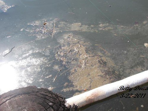
Three discharges of oil from Anglo-Suisse Offshore Partners' Platform E facility were reported to the Coast Guard, records show. The first came Friday, with a report of a "downed platform" and half a gallon of spilled crude during operations to plug and abandon the well.
Another report Sunday said the same incident had spilled 1.33 gallons of oil. A third report on Monday of 1.89 gallons of spilled oil was classified by the Coast Guard as "operator error."
Late Tuesday night, Houston-based Anglo-Suisse issued a statement acknowledging that the Coast Guard believes it may be responsible for the spill and accepting responsibility for cleanup. Anglo-Suisse said it was surprised because the well is "non-producing and has been monitored closely for the last six months." The company said it had reconnected the wellhead structure Tuesday morning and fully shut it in by 8:30 p.m.
The company said it was the 12th well in the area to undergo plugging and abandonment operations. Crews have been monitoring the site since September and didn't report any oil discharge until the end of last week.
Wildlife and Fisheries officials found the source of the oil Monday evening and encountered workers in a boat trying to restore a cap on the well using a remotely operated submarine.
"Well-capping went out of control," the state official said.
The well in question is in shallow water, about 210 feet deep, but the specter of any well-capping accident comes at the worst possible time for federal regulators, who have just approved the first four deepwater drilling projects since last spring's BP oil disaster -- mostly predicated on the oil companies' assurances that they can now cap their wells quickly in case of a blowout.
Environmental groups pounced on the symbolism of the latest spills.
"We have thousands of spills every year. The BP spill just called attention to it, but it's really the Wild West out here," said Anne Rolfes of the Louisiana Bucket Brigade. "There are laws on the books that are unenforced. The record is clear that we don't have the situation under control. It's taken several days to figure out where (the spill west of the river) is coming from, and if we don't have the technology to do that, then we shouldn't be drilling new wells at all."
According to federal government data, several wells in that 3-square-mile block were operated by Anglo-Suisse Offshore Partners LLC. A news release from the former federal Minerals Management Service said in 2006 that five wells in that drilling area had platforms damaged in Hurricane Katrina.
The state official said the spilling well is one that used to have a platform over it, but lost it during Katrina.

The Coast Guard, meanwhile, still isn't ready to say where the spill originated.
"We don't have any report of it actually being identified," said Coast Guard Petty Officer Steve Leeman.
At a news conference earlier Tuesday, Coast Guard officials said only between ¼- and ½-mile of beach was directly affected by oily material within the 30-mile stretch between Grand Isle and West Timbalier Island where the sheen and emulsified oil has been seen.
Michael Bromwich, director of the Bureau of Ocean Energy Management, Regulation and Enforcement, told reporters during a break in a conference in New Orleans earlier Tuesday that while officials with is agency had conducted a flyover of the affected area, the Coast Guard was handling the response and "exploring all possibilities."
"I think right now, it remains a mystery," Bromwich said.
By David Hammer, The Times-Picayune